
Wellesley ZIP Code Coverage
Three ZIP codes appear in the Wellesley postal context: 02457, 02481, and 02482. Each is a delivery label, not a municipal boundary map. 02457 is associated with Babson College and Babson Park, including the campus address at 231 Forest Street. 02481 is used for Wellesley Hills mailing addresses. 02482 is the general Wellesley postal label and is tied to the Wellesley Post Office at 1 Grove Street. The right ZIP should be verified against the complete address, not inferred from a neighborhood name.
| ZIP code | Wellesley context | Postal label or office | Important limit |
|---|---|---|---|
| 02457 | Babson College campus and Babson Park address context | Babson Park mailing label | Institutional ZIP, not a simple town boundary |
| 02481 | Wellesley Hills and surrounding mailing addresses | Wellesley Hills Post Office route | Postal place may differ from the municipality name |
| 02482 | General Wellesley postal service | Wellesley Post Office, 1 Grove Street | Postal result is not a parcel or town-line record |
USPS’s Wellesley Post Office listing confirms the 1 Grove Street location and the 02482-9998 postal designation shown in this capture.
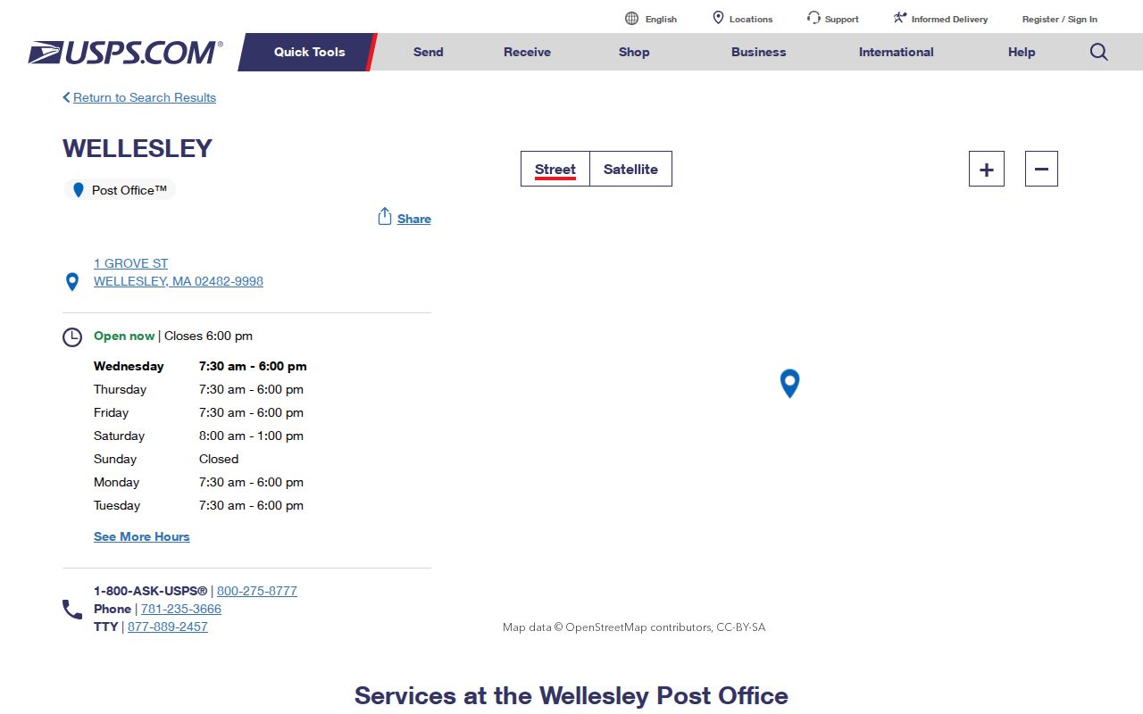
Use the official USPS result to check delivery information, then use the GIS property record for the town parcel and situs address.
Wellesley ZIP Code and Town Lines
Postal geography and town geography are different systems. A Wellesley-linked address can use the Babson Park 02457 label, the Wellesley Hills 02481 label, or the Wellesley 02482 label. Babson’s official pages place its campus at 231 Forest Street, Babson Park MA 02457, while student mail may use Wellesley Hills MA 02481. Those mailing facts should not be used to draw municipal limits, parcel boundaries, or a ZIP population count.
A USPS Postal Bulletin records a historical adjustment that changed an address last line from 02481 to Wellesley 02482. It is a useful warning that a postal last line can change without changing the property’s legal description.
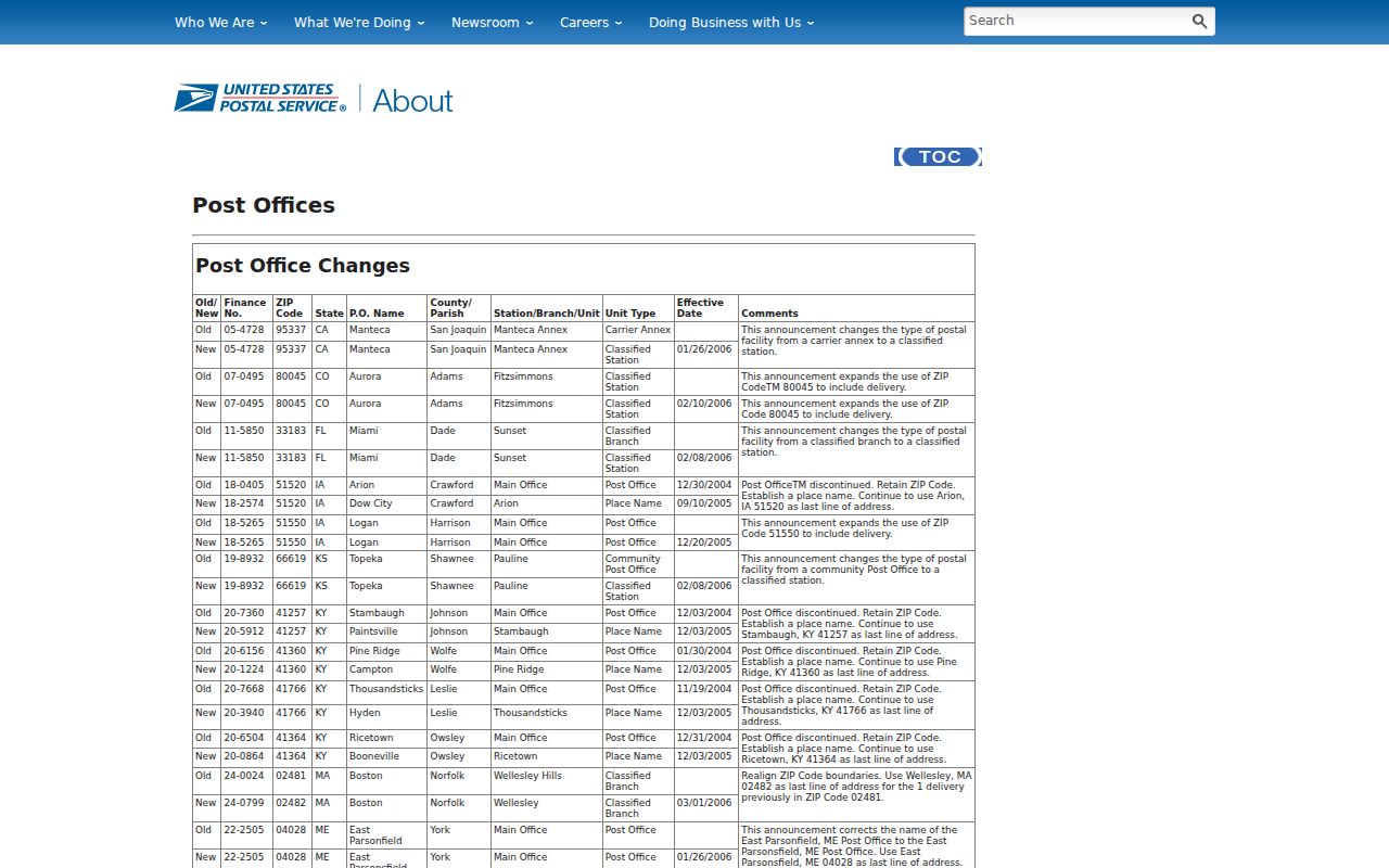
The bulletin documents a postal update. It does not establish who lived at the address or which town record holds a historic parcel.
Wellesley ZIP Code Lookup Steps
There is no official Wellesley ZIP-wide resident search in the research. The practical workflow is address-first. USPS verifies the postal address. The Wellesley GIS Property Viewer then identifies the parcel and current municipal geography. The Blue Book and List of Residents are organized by street and precinct, not ZIP. Norfolk Research may use address fields for applicable modern documents, but it is not a ZIP census. This avoids treating a delivery code as a list of people.
- Enter the complete mailing address in USPS address tools and record the postal label and ZIP.
- Search the address or parcel ID in the Wellesley GIS Property Viewer and confirm the situs address and parcel.
- Use the street and precinct for a local List of Residents or historical directory question.
- Use the Norfolk deed route only when a parcel or ownership chain is relevant, and match its legal description to the target lot.
Once a ZIP has narrowed the address, the Wellesley Streets page is the appropriate route for the street-level record chain.
Wellesley ZIP Search Fields
ZIP is a field in some official tools, but its role varies. The Massachusetts voter-status search accepts a five-digit ZIP only with an individual’s first name, last name, date of birth, and agreement. It does not return a ZIP-wide directory. The Wellesley GIS guide documents address and parcel-ID searches, not a confirmed ZIP filter. Use those limits as part of the search design rather than expecting one portal to map every person in a ZIP.
| Official tool field | Input type | Required role | ZIP-related limit |
|---|---|---|---|
| Massachusetts voter status ZIP | Five-digit text or number | Required with name, birth date, and agreement | Individual status check only |
| GIS address | Address search | Optional search route | Not a confirmed ZIP browse filter |
| GIS parcel ID | Parcel identifier | Optional search route | Bridges a ZIP address to town parcel data |
| Property-card mailing ZIP | Displayed record field | Shown where available | May differ from the situs address |
The GIS viewer can also display parcels, address numbers, voting precincts, school districts, zoning, flood and wetland layers, buildings, and aerial imagery. Those layers provide record geography, not a ZIP resident count.
Wellesley ZIP Code Map Layers
After a Wellesley ZIP code is confirmed, the Wellesley GIS Property Viewer supplies the local map layers that give the address a civic and physical setting. Wellesley Assessor Parcels and Wellesley Address Numbers help match the street to a municipal parcel. Wellesley Voting Precincts and Wellesley School Districts show administrative geography. Wellesley zoning, Wellesley floodplain, Wellesley wetland, Wellesley public-land, Wellesley building, and Wellesley aerial layers answer still different questions. None of those Wellesley layers is a ZIP polygon, but together they test whether a postal label has been confused with a local boundary.
The Wellesley GIS guide allows a Wellesley user to search by address or parcel ID, choose a Wellesley map location, view Wellesley Assessor Parcels, and open the Wellesley Property Record Card through More Info. Measure and print tools are useful for rough Wellesley map work but do not create a filed survey. When a Wellesley street name or Wellesley lot has changed, use the Wellesley map layers with the Wellesley historical map series and the Wellesley deed legal description.
Wellesley ZIP Address Terms
Address terms often look interchangeable but they are not. The current GIS property card can show both a mailing address and a property or situs address. Norfolk deeds use the legal description and plan references to anchor the parcel through a street-name change or lot split. USPS applies a ZIP to a postal address. Labeling those fields separately prevents a tax-mailing address or postal last line from being mistaken for the physical place or the deed’s controlling description.
- ZIP and ZIP+4
- A ZIP directs mail to a delivery area; ZIP+4 adds a smaller delivery segment. Neither is a legal parcel boundary.
- Unique ZIP
- A postal code associated with a single institution or organization context, such as the Babson Park 02457 situation.
- Carrier route
- A postal delivery grouping used for mail service. It is not a town precinct or a household census.
- Situs address
- The physical property address used for the municipal parcel record, which can differ from a mailing address.
Garden Road and Wellesley ZIPs
Garden Road illustrates why an old address cannot be reconstructed from a modern ZIP label alone. The Historical Society notes that Garden Road does not appear on the 1897 map but does appear on the 1919 map. Before 1881, Wellesley was part of Needham and West Needham, so an earlier record may be indexed under those locality names. The 1856 Needham map, 1897 Atlas, 1919 and 1927 Sanborn sheets, and the Street Name Index provide a chronological map stack that a postal lookup cannot replace.
Wellesley’s town history gives the incorporation context for these locality changes.
For historic work, record the street name, map year, old locality name, and legal description alongside the postal address.
Wellesley ZIP Code Directory Limits
A ZIP code directory can help verify a mailing label, but it cannot establish a complete household list, ZIP population, town boundary, voter count, or ownership chain. Official sources did not provide a Wellesley ZIP-boundary polygon, ZIP-by-ZIP population, or ZIP-by-ZIP registration count. The town’s QuickFacts population should not be divided among postal labels. Likewise, a parcel’s location on a town GIS map should not be inferred from the USPS last line.
Use the right geography. USPS answers a delivery question. Wellesley GIS answers a parcel and municipal-map question. Norfolk deed records answer a legal-description and transfer question. The same address may require all three.
Historic directories and Lists of Residents are organized by name, street, and precinct patterns. They provide a better local route than a postal code when the goal is a dated resident association.
Wellesley ZIP Code History
Wellesley ZIP code research has a date problem as well as a map problem. The documented Wellesley ZIP range appears in a 2012 USPS bulletin as 02457 and 02481 through 02482. A 2006 postal bulletin records a Wellesley delivery adjustment. Historic Wellesley maps have their own dates: the 1856 Needham map predates the town, the 1897 Wellesley Atlas predates Garden Road’s documented appearance, and the 1919 Wellesley Sanborn sheets show a later street grid. A Wellesley postal label from one year should therefore be recorded beside the Wellesley map or Wellesley directory year used for the same address.
Wellesley postal geography does not replace Wellesley record history. The Wellesley Town Directories begin in 1883, Wellesley Lists of Residents begin in 1902, and Wellesley Townsman coverage begins in 1906. Those Wellesley series can tie a name to a Wellesley street or precinct at a date. USPS can then confirm how a current Wellesley mailing address is formatted. The two systems complement each other without becoming the same dataset.
Wellesley ZIP Code Record Trail
After USPS confirms the mailing form, preserve the street, ZIP, and verification date, then move to the source that owns the next fact. The GIS property card can show current parcel fields. Norfolk Research can trace a deed by grantor, grantee, book and page, plan, document type, town, or date, with older address searching generally limited to documents from 2003 onward. For a historical household, use the Wellesley Town Directories from 1883 forward and the Lists of Residents from 1902 forward, then compare them with maps and the Townsman archive.
This sequence keeps the Wellesley ZIP code directory in its proper role: a postal verification layer within a broader local records trail.